
‘Brave New World of News Maps’ by Bruce Brown
No Facet of the news industry has changed more since the turn of the century than news mapping.
FOR CENTURIES, the best news maps were small, fixed, single magnification approximations of the actual geographic reality that were hard-to-impossible to modify and showed, at best, stylishly rendered relationships between identified items and/or locations.
But today, the best online news maps are precise in their accuracy, global in scope and infinite in their magnification, allowing the user to pan and zoom at will. They also allow the user to customize the view by changing the base map layer from, say, satellite to street map, as well as selecting which overlay layers are displayed to isolate aspects of the map for closer inspection. Many other functions that are impossible in traditional maps can also be programmed in to modern news maps, such as popup labels, calculating the distance between two or more points, and location of the viewer in real time on the map.
Maps have always been uniquely powerful tools for revealing relationships in a story, but they have almost always served a supporting, illustrative role. Modern news maps fulfill this traditional map role better than ever by doing things that couldn’t be done before. For instance, take local news. Rather than simply publishing the address of a fire, which may be meaningless to most people, modern news maps help generate readership/traffic for news stories by easily and accurately identifying the location of news events on a map, which was impossible with old news mapping. The Bellingham Herald is one small market newspaper that does this today.
But actually, this is just the beginning. Today, for online news publications, dynamic, interactive custom news maps have become so strong and compelling a tool that the maps can actually become the main device for carrying and maintaining the narrative of a complex, evolving global news story like the disappearance of Malaysian Airlines Flight MH370 and the meteoric rise of ISIS in Syria and Iraq. Today, maps are good enough to be the main act.
Google developed much of the underlying technology that enables modern online mapping — called AJAX, an acronym for asynchronous JavaScript + XML — shortly after the turn of the century, and first implemented in it Google Maps in 2005. Thanks to Google, people today have come to expect dynamic, interactive and customizable mapping. With younger people especially, the conventions of dynamic mapping are all immediately understood. It’s part of the visual language of our times.
For online news organizations, there are some additional attractions in modern news mapping. Modern online news maps can be modified easily and infinitely, which saves time and money for the publisher. And because they are global in scope, they can be be effortlessly expanded and refocused, which also saves time and money by allowing the creation of one complete map instead of many small, incomplete maps — essentially, one map to rule them all.
With modern online news maps, it also possible for online news organizations to sell display ads on the maps as well as paid link locations on the maps, expanding their potential ad sales base while improving the quality of their news product — a clear win-win situation for online news organizations!
For all these reasons, dynamic, interactive custom map-making with JavaScript and AJAX is expected to take over news mapping for online news organizations in the next few years. This will mean new jobs in the news sector, but jobs of a new sort, requiring new skills (such as a working knowledge of JavaScript) to achieve old ends.
Institutions of higher learning that want to give their journalism students a chance for these new jobs will need to offer a curriculum that trains them in modern news map making skills.
Here are some examples — with discussion — from the Los Angeles Times, Slate, Al Jazeera, Bellingham Herald and Astonisher.com…
Google news mapping solutions…
Pros: Slick, capable and relatively easy to implement because the controls are pretty much wrapped in a UI.
Cons: Google’s Terms of Service prohibit commercial use without a license from Google.
Also digital maps are nowhere as long lasting as traditional maps, which can survive for centuries. Please note that just five years after this story was originally published, most of the links below no longer connect to working digital maps.
The main reason for this is that the underlying map tiles for these maps are no longer free. For instance, there are no free satellite maps tiles available for Leaflet any longer, despite the fact that all satellite map tiles were originally created with public tax dollars. These publicly created maps have been captured by for-profit corporations and organizations, which now charge the public for images that the public paid to create in the first place!
* Bellingham Herald using Google
* Al Jazeera using TerraMetrics/Google
Open-source JavaScript news mapping solutions with Leaflet in the media today…
Pros: Free, without ANY use restrictions, and much slicker than Google as a narrative story tool. Also allow the publication to control all rights, ad sales and commercial links through the maps, NOT Google.
Cons: require JavaScript programming and are therefore much more difficult to implement.
Also, digital maps are nowhere as long lasting as traditional maps, which can survive for centuries. Please note that just five years after this story was originally published, most of the links below no longer connect to working digital maps.
The main reason for this is that the underlying map tiles for these maps are no longer free. For instance, there are no free satellite maps tiles available for Leaflet any longer, despite the fact that all satellite map tiles were originally created with public tax dollars. These publicly created maps have been captured by for-profit corporations and organizations, which now charge the public for images that the public paid to create in the first place!
* Slate picking up WNYC PBS-TV in New York using Leaflet
* Los Angeles Times picking up LongWarJournal.com data using Leaflet
Bruce Brown’s Astonisher.com JavaScript news mapping with Leaflet…
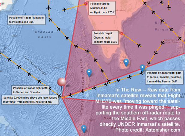
* Malaysian Airlines Flight MH370: Four Off-Radar Routes to the Middle East
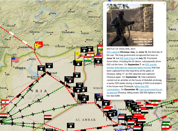
* The War of the Caliphate in Syria & Iraq, 2014
Open-Source JavaScript map / story solutions built on Leaflet…
* Al Jazeera using StoryMapJS
* Al Jazeera using OdysseyJS
* Al Jazeera using CartoDB
* Al Jazeera using animated JS
 |  |  |  |