Maps Updated August 26, 2010 --
New Galbraith Mt. Trail Maps!
GALBRAITHMT.COM'S satellite and GPS technology-based Galbraith Mt. Trail Map Set has three parts:
|
|
|
|
| Subscribers can click the links below to go directly to the Maps... |
| 1 |
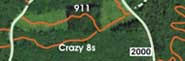 |
Big Naked Trail Map, which is great when you want to really see the entire mountain and all the trails -- naked, so to speak. |
|
|
|
| 2 |
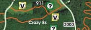 |
Big Bells & Whistles Trail Map, with hot links to all our Trail Guides, Technical Notes and Video Clips -- This IS "The Ultimate Galbraith Mt. Guide." |
|
|
|
| 3 |
 |
Printable Trail Map, which prints the entire mountain on a single sheet of paper. Print it and take it with you on the trail -- if it gets trashed, just print another! |
|
|
|
|
|
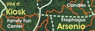
NOTE: Because of the extensive logging on Galbraith over the last several years, these maps are no longer accurate. Most of the trails still exist, but many have different routes and connect in different places.
|


