|
||||||||||||||||||||||
| Some Quick Tips... Before Printing Your Galbraith Mt. Trail Map...
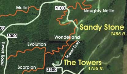
You may find the map is clipped when printed if you don't turn off the "print HTML headers and footers" option in your browser. To do this in Firefox and Internet Explorer, go to File > Page Setup > Margins and Headers/ Footer. Click here for the printable, 8 1/2 x 11 inch GalbraithMt.com Map. Once you have displayed the page with the map in your browser, just go to File > Print. Here's the big basic version of the map, which is great when all you want to see is the mountain and the trails, naked so to speak. Here's the big bells and whistles version of the map, with hot links to all our Trail Guides, Technical Notes and Video Clips. You can use this version online to really get to know the mountain. -- Mongo NOTE: Because of the extensive logging on Galbraith over the last several years, these maps are no longer accurate. Most of the trails still exist, but many have different routes and connect in different places. |
||||||||||||||||||||||


|
Please read GalbraithMt.com's Terms of Use. © Copyright 2000-2011 by GalbraithMt.com. All rights reserved. BF Communications Inc. Website by Running Dog |
 |
|||
| Rides: 220 | Total vertical feet climbed: 404,900 | ||