Maps Updated
January 20, 2010 --
New Galbraith Maps!
The best, most complete and up-to-date Mt. Bike Maps of Galbraith Mountain in Bellingham, WA
New Trail Guides too!

GalbraithMt.com's Ultimate Galbraith Mt. Guide
Click for Galbraith weather & webcams. You must be connected to the Internet...

Driving Directions...
From Interstate 5 to Galbraith Mt.

HERE'S ARE road maps, driving directions and the latest freeway exit Webcam photos from WSDOT to help you navigate from Interstate 5 to both the North Side and the South Side of Galbraith. Click here for Galbraith Weather and more Webcam shots. Click for Galbraith Mt. Weather and Webcams
Click for Galbraith Mt. weather...

The South Side
if you're goin' to Shawn's Trail, 911, Polka Dot, Kung Fu Theater, Purple Heart, Wonderland, Woopsie Woodle, Scorpion, Evolution, etc.


Detail from Mapquest Map
DOT Webcam view of I-5 at Lake Sammish Bellingham Park and Ride
Directions: Get off I-5 at the North Lake Samish Exit (Exit 246)...
Step 1: Exit Interstate 5 at the NORTH LAKE SAMISH EXIT (EXIT 246)
Step 2: If you were heading NORTH on I-5, turn LEFT onto SAMISH WAY.
If you were heading SOUTH on I-5, cross OVER the freeway on the two-lane road that becomes SAMISH WAY on the other side of I-5.
Step 3: Continue on SAMISH WAY about 100 feet past the SAMISH WAY / GALBRAITH LANE intersection, and park on the other side of SAMISH WAY in the Upper Lake Padden Park parking lot.
Approximate Drive Time: 4 minutes
Approximate Distance: 1.5 miles
WDOT Webcam: Here's the latest picture from the WDOT Webcam at Exit 246 on I-5. The view is toward the north, and the exit lane in the foreground is the north bound exit for Galbraith Lane. The south bound exit is just out of the picture to the left.

The North Side
if you're goin' to the Ridge Trail, Bob's Trail, Family Fun Center, Cedar Dust, Candies, El Pollo Elastico, Arsenio, Purple Heart, etc.


Detail from Mapquest Map
DOT Webcam view of I-5 at Bellingham Lakeway Drive exit
Directions: Get off I-5 at the Lakeway Drive Exit (Exit 253)...
Step 1: Exit Interstate 5 at the LAKEWAY DR. EXIT (EXIT 253).
Step 2: If you were heading NORTH on I-5, turn RIGHT at the stop sign at the end of the Freeway off ramp, then turn LEFT onto LAKEWAY DR. at the stoplight.
If you were heading SOUTH on I-5, turn left onto LAKEWAY DR. at the light at the end of the freeway off ramp.

Step 3: Turn SLIGHT LEFT onto ELECTRIC AVE.

Step 4: Turn LEFT onto ARBOR CT.

Step 5: Turn RIGHT into the Whatcom Falls Park parking lot and park near the tennis courts.
Approximate Drive Time: 5 minutes
Approximate Distance: 1.75 miles
WDOT Webcam: Here's the latest picture from the WDOT Webcam at Exit 253 on I-5. The view is toward the south, and the exit lane in the foreground is the north bound exit for Lakeway Dr. The end of the south bound exit off ramp is barely visible in the upper right corner.

Great Galbraith Mt. Riders: Jim "Sully" Sullivan at the 1990 Mt. Bike World Championships in Durango, COGreat Galbraith Mt. Riders: Mark Peterson on Cedar Dust in the snowGreat Galbraith Mt. Riders: Mark Peterson on Cedar Dust in the snowGreat Galbraith Mt. Riders: Mark Peterson on Cedar Dust in the snowGreat Galbraith Mt. Riders: Dan Waters on Evolution by MongoGreat Galbraith Mt. Riders: Russ Barlow at Sandy Stone by MongoGreat Galbraith Mt. Riders: Chris Luna at Sandy Stone by cartman88Great Galbraith Mt. Riders: Pat "The Bear" White on the Big Rock on Cedar Dust on Galbraith Mt. in Bellingham, WAGreat Galbraith Mt. Riders: Russ Barlow at Sandy Stone by MongoGreat Galbraith Mt. Riders: Pat "The Bear" White on the Big Rock on Cedar Dust on Galbraith Mt. in Bellingham, WA


Map get trashed? Print another!

cover of GalbraithMt.com's Ultimate Galbraith Mt. Guide
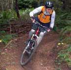
You don't have to get lost. You don't have to ride the same couple trails over and over again.

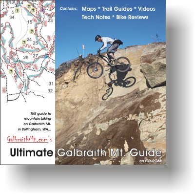
Get GalbraithMt.com 's Galbraith Mt. Trail Map Set & Ultimate Galbraith Mt. Guide -- you'll get more out of the mountain.

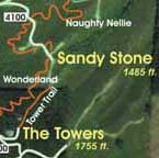
This is THE guide to mountain biking on Galbraith Mt. in Bellingham, WA, and it includes the best mountain biking maps of Galbraith ever made, updated August 2009.

You get all our Trail Guides, Technical Guides, Bike Reviews, Virtual Greeting Committee and Video Clips, PLUS the complete Galbraith Mt. Trail Map Set.

And because the Ultimate Galbraith Mt. Guide is electronic, you can print out as many copies of the maps as you like. Did the one in your pack get trashed? No problem. Just print another! Check it out, or Buy It Now!

GalbraithMt.com online edition
CLICK PayPal VISA/Mastercard button to buy a one-year online subscription to the Ultimate Galbraith Mt. Guide -- featuring 24 Trail Guides covering 44 trails and including the best, most up-to-date Galbraith Trail Maps ever made -- on GalbraithMt.com for $14.95 complete. Click here for more info...
To speak to our Circulation Dept., please call (360) 927-3234 (local call in the Bellingham, WA area).


Maps    Trails    Technical    Gear   Gallery   Bikes    Video 


Please read GalbraithMt.com's Terms of Use.

© Copyright 2000-2010 by GalbraithMt.com. All rights reserved.
GalbraithMt.com is a trademark of BF Communications Inc.

BF Communications Inc.
P.O. Box 393
Sumas, WA 98295 USA
(360) 927-3234

Website by Running Dog


Vert Quest, excerpts from Mongo's World Record Journal by Bruce Brown "Mountain In The Clouds" by Bruce Brown